Apr 10 2017
 Credit: Homeland Security's Science & Technology Directorate
What if there is an oil spill a number of miles from the coast of Alaska? In order to alleviate the destruction of the local fisheries and environment, it is highly crucial to control the spill in time. However, the autumn sea ice is on the rise. The spill is surveyed by the U.S. Coast Guard by sending an aircraft. The increasing quantity of ice on the surface of water significantly restricts the visibility. Consequently, response attempts take more time and are not much comprehensive, thus increasing the amount of destruction of the nearby communities as well as the ecosystem.
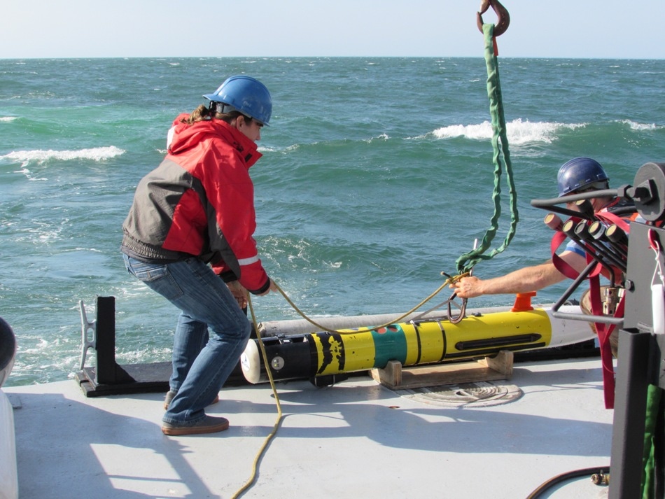
In order to aid the Coast Guard to overcome the prospective disaster, the Department of Homeland Security (DHS) Science and Technology Directorate (S&T) is working in collaboration with the Arctic Domain Awareness Center (ADAC) and Woods Hole Oceanographic Institution (WHOI) to create the Tethys Long Range Autonomous Underwater Vehicle (LRAUV). ADAC is one among S&T’s Centers of Excellence (COEs).
Although the LRAUV is only in the prototype phase to date, it is intended to aid in the under-ice data gathering attempts. Until now, WHOI has created search algorithms and arrayed sensor packages. At present, it has used the Tethys platform to join the sensors with an innovative LRAUV model. The platform can be easily installed by two people, can reach an unparalleled 600+ KM range at about two knots speed, and does not need any special handling equipment for installation or recovery.
We are creating robotic systems that are small, mobile, connected and enduring, making them a perfect match for the remote Arctic. Our goal is to give the Coast Guard the ability to understand an incident while there is still time to react.
James G. Bellingham, Director of WHOI’s Center for Marine Robotics
Upon completion, the LRAUV will function as a propeller-driven robot that can be used in conditions deemed to be too risky for humans. The unique design of the LRAUV enables it to be transported by means of a helicopter and pitched into an open water area, from which point it has the ability to guide itself to the site of environmental hazard. Once the platform is installed, a long-range maritime antenna buoy is positioned in the water by response teams to enable relay of information back to an on-shore coordination center. Then, the LRAUV sends three-dimensional mapping of spill sites from below the ice layer, thus generating complete data that cannot be obtained through overhead imaging methods. The data can be used by the Coast Guard to more swiftly create comprehensive response strategy. Therefore, obtaining precise information from the LRAUV in time would be a crucial component in the response strategy.
The Propeller Driven Long Range Autonomous Underwater Vehicle (LRAUV) provides USCG Arctic operators the ability get readily sensors on scene, under sea ice, and map a spill at remarkably long distances ... all without needing special handling equipment.
Major General Randy “Church” Kee, ADAC Executive Director
Characterization of the nature and extent of an oil spill can prove to be challenging even in ice-free and logistically approachable oceans. This was apparent in the case of the 2010 “Deepwater Horizon” oil spill in the Macondo Canyon, which led to the release of an enormous amount of petroleum into the Gulf of Mexico. In this case, the response strategy was aided by the early generation remotely controlled underwater vehicles that assisted in the characterization of the nature of the well blow-out. Although the time and range of the underwater vehicles was limited on-station, they were highly convenient for use by on-scene operators and motivated further scientific discovery and development.
Integral to effective response operations is knowledge of where the oil is and predicting where the oil may go. With better real time data, more effective response strategies can be developed and deployed. Given the additional complexity of conducting response operations in ice infested waters, whether in the Arctic or in the Great Lakes, having the ability to detect and characterize the oil extent under ice can greatly enhance effective response actions.
Captain Joseph B. Loring, Chief of the Coast Guard’s Office of Marine Environmental Policy
As a consequence of the increase in commercial development and traffic in the Arctic, the risk of oil spills is also on the rise. Alleviation of the potential destruction due to environmental hazards will prove to be highly challenging because of the peculiar regional difficulties: limited ports, long travel distances, seasonal sea ice, very less expeditionary launch structures, and remoteness from assets all contribute toward the complication of response strategies. Gratefully, the developments carried out on the LRAUV can assist in ensuring that the Coast Guard will have an information-gathering potential matched to overcome the Arctic obstacles, in the future.
Similar to ADAC, S&T’s COE work in close collaboration with the homeland security community to create customer-driven, innovative tools and techniques to overcome real-world difficulties. Headed by the University of Alaska Anchorage, ADAC creates and alters innovative products, technology solutions, as well as educational programs to enhance crisis response abilities and situational awareness with respect to emerging maritime difficulties caused due to the dynamic Arctic environment.