Nov 1 2016
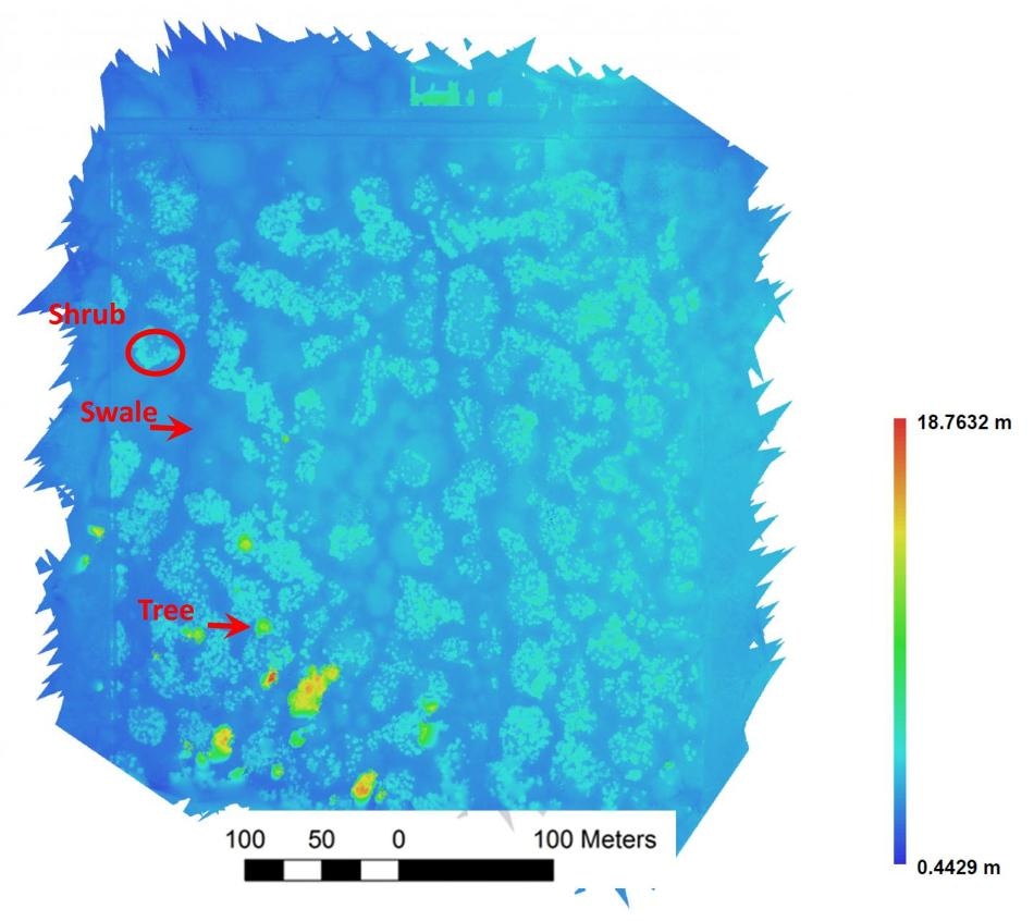
 This is a digital surface model of the vernal pool region of the Whetstone Savanna Preserve in southern Oregon generated from aerial images collected using a small drone. (CREDIT: Mitchell B. Cruzan, Ben G. Weinstein, Monica R. Grasty, Brendan F. Kohrn, Elizabeth C. Hendrickson, Tina M. Arredondo, and Pamela G. Thompson. 2016. Small unmanned aerial vehicles (micro-UAVs, drones) in plant ecology. Applications in Plant Sciences 4(9): 1600041. doi:10.3732/apps.1600041)
Although long-term, broad-scale ecological data are vital for plant research, they are most often not easy to collect manually. The most commonly adopted data-collection techniques can turn out to be dangerous or time consuming, and can compromise habitats that are delicate to human impacts. These limitations pertaining to data-collection can be overcome with the help of micro-unmanned aerial vehicles (UAVs) or drones that can fly over an area and collect unobtrusive aerial image data.
A new analysis highlighting when and how to use drones in the domain of plant research has been published in the recent issue of Applications in Plant Sciences.
The potential of drone technology in research may only be limited by our ability to envision novel applications.
Mitch Cruzan, lead author of the review and professor in the Department of Biology at Portland State University
Drones possess the ability to accumulate vegetation data over years or seasons and can help in monitoring threatened and rare plant populations, habitat restoration efforts, measuring carbon storage and also in surveying agriculture. "This technology," says Cruzan, "has the potential for the acquisition of large amounts of information with minimal effort and disruption of natural habitats."
For few research queries, drone surveys serve as a vital source of ecological data. Images that are captured using drones possess the ability to map all species in the landscape based on the uniqueness of the spectral light values that are generated from flower colors or plant leaves. Drones can also be coupled with 3D technology in order to track a plant’s size and height. These images will be of help to scientists who are trying to track diseases, study a plant’s health, reproduction and phenology, and inspect human-mediated habitat disturbances
Small drones can be flown along set boundaries over study areas ranging up to 40 hectares. Researchers can obtain high-resolution, repeatable images because of an internal GPS system that allows drones to hover over pinpointed altitudes and locations. However, Cruzan and his colleagues alert other researchers of shadow gaps while collecting data. Taller vegetation covers possess the ability to obscure shorter vegetation and as a result are not visible in aerial photographs. This necessitates the requirement of overlapping images to obtain right angles in order to capture a complete view of the landscape.
The review demands desired features and additional operator and drone requirements, including camera stabilization, video feeds and wide-angle lenses for data collection over larger areas. It is also necessary to possess metadata on the drone's speed, altitude and elevation of every captured image.
After completing data collection, georeferenced images are stitched together to form a digital surface model (DSM) that has to be analyzed. Manual, automated or machine-learning techniques are used by programming software and GIS to classify landscape features, vegetation types and also individual species in the DSMs.
Cruzan and colleagues used drone technology to a landscape genetics study of the Whetstone Savanna Preserve in southern Oregon, USA in order to analyze the effectiveness of drones. "Our goal is to understand how landscape features affect pollen and seed dispersal for plant species associated with different dispersal vectors," says Cruzan. Researchers flew drones over vernal pools that are threatened, seasonal wetlands. The obtained drone images were studied to discover how landscape features facilitate plant dispersal and gene flow in these patchy habitats. Manual mapping of these habitats might have compromised these ecologically sensitive areas and also would have taken hundreds of hours to map.
Before the advent of drones, light detection and ranging (LiDAR) was the main choice for aerial imaging data. LiDAR makes use of remote sensing technology to obtain aerial images. However, LiDAR demands highly specialized flyovers and equipments, and is expensive and most often used to obtain data from a single point in time.
LIDAR surveys are conducted at a much higher elevation, so they are not useful for the more subtle differences in vegetation elevation that higher-resolution, low-elevation drone surveys can provide.
Mitch Cruzan, lead author of the review and professor in the Department of Biology at Portland State University
The new drone technology is affected by some limitations. Even if buying a robotic drone is more affordable than alternative aerial imaging technologies, one might have to initially invest over US$1,500. Additionally, national flight regulations even now limit drone applications in some countries because of restricted flight elevations and flyovers near or on private lands and changing licensing regulations. Manual data collection will become a necessity if researchers are trying to study plant species that cannot be spotted in aerial images using spectral light values.
According to Cruzan, despite limitations, the biggest perk of robotic drone research is its flexibility. If the scale and questions of the study are ready to take advantage of drone technology, then "using a broad range of imaging technologies and analysis methods will improve our ability to detect, discriminate, and quantify different features of the biotic and abiotic environment." As drone research advances, access to better equipment hardware and open-source analytical software programs will help researchers to make use of the advantages of drone technology in plant ecological research.