Sep 7 2010
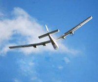
MAVinci, a German company partnering with ESA has released unmanned Micro-Air Vehicles (MAVs) facilitating effective inspection of terrains and catastrophic areas. Previously these vehicles were utilized to combat soil erosion by Spanish cultivators in Andalusia. The length of the aircraft wings measure less than two meters.
Johanna Born, CEO of MAVinci has stated that the manned aircrafts utilized by the present remote sensing sector are costly and can not be readily availed. He added that their MAVs are cost- effective and can be availed on a short prior notice. They can be easily employed in monitoring various areas including garbage dumping sites, adverse zones, construction areas etc. MAVs include both thermal and optical cameras and they can also carry other evaluation equipments specified by the customer.
 MAV for remote monitoring
ESA’s Technology Transfer Programme Office at the Business Incubation Centre, Germany hosted MAVinci in developing this unmanned spacecraft. With the help of satnav data, the ESA experts delivered algorithms for the calculation of attitudes. MAVinci, with the help of ESA’s optical lab standardized the visual camera.
According to Michael Flegel, ESA’s Flight Dynamics Engineer, the principles used by the satellites and unmanned aircrafts like MAVs in concluding the altitude are the same and the only factor that varies is the scale employed. He added that satellites employ the calculated direction of the earth, sun or other star designs and the MAV will utilize the direction of the local magnetic field and other analogous local measurements. Flegel concluded that the retrieval of significant information from the overall data demands proficiency.
MAV is controlled by an autopilot right from take off till landing. The aircraft follows a predetermined track by utilizing satnav and the picture of the target zone is captured by means of the visual camera. With the help of a radio, MAV is monitored from the base by a pilot who can carry out the manipulations at any point of time.