Mar 23 2016
A combination of both humans and computer intelligence could win a real-life game of “Where’s Waldo”. This is what is suggested by a new study, that revealed when precision and speed are equally important, a method integrating both human intelligence and machine intelligence would win the prize.
 Drone images accumulate much faster than they can be analyzed. Researchers have developed a new approach that combines crowdsourcing and machine learning to speed up the process.
Increasingly drones are being utilized to track a range of factors, such as pollution, natural disaster sites, wildlife populations, etc. Real-time analysis of drone images has turned out to be a crucial big data challenge.
A research team, including EPFL’s Stéphane Joost, presented an innovative method to quickly understand aerial images captured by camera drones. The drones integrate both machine learning and human crowdsourcing. The study has been published in the Big Data journal.
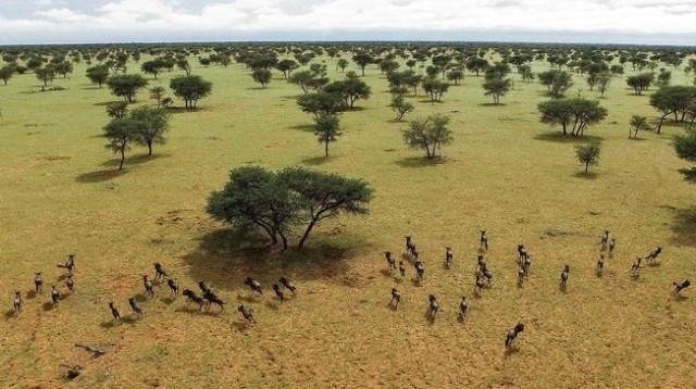
In order to develop and test their method the team initially went to the Kuzikus wildlife reserve, which is located in the hub of Namibia. They examined the compound using camera-drones to compute the existing wildlife population, such as rhinos, zebras, ostriches, wildebeests, and kudus. The researchers obtained a huge number of images, which made it difficult to consistently differentiate between animals, bushes, and rocks through computers. They used an online crowdsourcing platform called www.micromappers.org to upload their images for physical analysis by a group of digital volunteers. A simple task was placed before the digital volunteers, where they have to click through a set of images, detect all the animals, and highlight the same on their respective screens.
Within two days, they had evaluated 98% of the 26,000 images that had been uploaded.
Stéphane Joost, EPFL
Next, half of these annotated images were used to train an automatic object recognition algorithm, which was then tested on the remaining images.
The 500 digital volunteers did generate a number false positives, tracing features that in actual fact were not animals. Despite that, their analysis was certainly good enough to serve as training data for the computer algorithm.
Stéphane Joost, EPFL
Essential aid following disasters
With respect to disaster response operations, artificial intelligence already plays a major role, it is often used to search text messages and tweets for what can prove to be life-saving data.
Twitter can erupt with up to tens of thousands of tweets sent out of the disaster zone per minute. It would take humans days to sort the relevant from the irrelevant information. Today, this challenge has been solved and tweets can be analyzed quickly using a combination human and artificial intelligence. Our challenge was to transpose this solution to apply it to the analysis of image data.
Stéphane Joost, EPFL
At high altitude, drones equipped with high-resolution cameras serve as a useful vantage point to rescue workers, allowing them to detect blocked roads, damaged buildings, and other major aspects. When compared to spotting infrastructure affected in a disaster, automatic identification of animals in the Savanna would probably be much more complicated.
After completing the pilot study in Namibia, the tool was utilized in its first crucial mission: the World Bank used it to expedite needs assessment and damage following the tropical cyclone Pam, which stuck the Island State of Vanuatu in the year 2015.
An exceptional list of authors
It is interesting to point out that three of the study’s co-authors were, at the time, environmental engineering students. Nicolas Rey, Julien Briant, and Pauline Millet were attending a course in territorial imagery at EPFL, where they developed some of the detection algorithms used in this project.
Stéphane Joost, EPFL
It is quite rare for students to become co-authors of scientific research articles.
The research was performed by scientists from EPFL, the Kuzikus Wildlife Reserve in Namibia, the Qatar Computing Research Institute, and the University of Zurich, in partnership with Drone Adventures.