Jan 28 2011
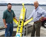
CSIRO has deployed a coastal glider in Moreton Bay to examine the effect of latest flooding on the ecosystem in marine waters.
Dr Andy Steven from CSIRO's Wealth from Oceans Flagship has stated that the glider will enable them to study the extent of recent flood trail on Moreton bay as well as analyze its effects. He mentioned that the devastating flood helps them to comprehend how marine environments react to huge inflow of sediments and fresh water. He added that the glider will develop 3-D maps depicting the effect of the flooding on the marine ecology.

According to Dr. Thompson, Biological Oceanographer of CSIRO, the glider has a group of sensors which can help them to see through the cloudy rubbish and mud scattering through Moreton Bay. He added that this will enable them to generate prediction models highlighting how the marine system is being affected now and how it will be disturbed in future.
Dr Steven has mentioned that the information received from daily surveys will be utilized along with satellite images and other information. He said that the images of satellite can evidently reveal the surface designs of turbid water and nutrients. He added that sub-surface view of the water is offered by the glider.
CSIRO has partnered with the Queensland Department of Environment and Resource Management, the Healthy Waterways Partnership and universities. Combined research teams are working in the Moreton Bay to gather water samples to supplement the data obtained from the glider, satellite images and ongoing monitoring operations.
The researchers are also focusing on setting up incessant moorings at major areas to supply present health conditions of the bay. The data will enable them to understand the flood trail dynamics and its possible impacts on fish, sea grass, turtles, coral and other marine plants and animals. It will also highlight on the bay’s flexibility following this extreme incident.