Nov 6 2015
A new remote satellite monitoring programme, powered by UK technology and expertise has been launched to help conserve a unique, fragile ecological corridor in the Caribbean.
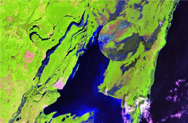
 Landsat-8 Shortwave Infrared Composite (6,5,4) image of Lake Bacalar, Mexico
Laguna Bacalar in the Mexican state of Quintana Roo is a 42km long lake renowned for its unique white limestone bottom and clear freshwaters. The wetland between the Laguna and the Chetumal bay, called the Bacalar corridor, is rated as the highest at-risk conservation area in the Caribbean ring, in need of immediate intervention to help preserve its important ecosystem.
Surrey Space Centre (SSC) at the University of Surrey will lead the project, funded by the UK Space Agency (UKSA) within the International Partnership Space Programme, that will use satellite data from UK/EU assets and locally sourced environmental information to enable near-real-time monitoring and impact analysis to help support environmental interventions by the Mexican government.
In collaboration with the Mexican Space Agency (AEM) and UKSA, SSC will lead the UK consortium made of Surrey Satellite Technology Limited, Satellite Applications Catapult and Deimos Space UK Limited, to deliver Earth Observation for the UK Climate, Environment and Monitoring from Space (CEMS) platform. This observation will analyse the impact of human activities in the Bacalar corridor, both in terms of conservation and ongoing harmful activities.
“The transverse coastal Corridor in the south-eastern Yucatan Peninsula is a complex system consisting of different ecosystems, while also being a popular tourist destination. This is one of the challenges Mexico faces: protecting the area while ensuring visitors can continue to enjoy it for generations to come,” commented Dr Raffaella Guida, Senior Lecturer in Satellite Remote Sensing at the University of Surrey and PI on the project.
She continued, “Human activities are clearly having an impact on this delicate ecosystem. Monitoring the effect of these activities is urgent and represents one key deliverable for the project. SSC and its partners monitor this activity using satellite imagery and help provide evidence and support for a Mexican application which seeks to assign Laguna Bacalar as an International Relevant Wetland.”
“Data from the Copernicus constellation, specifically from Sentinel-1 and Sentinel-2, will be used in addition to Deimos-2 data to produce maps of the area showing, for example, how the land is currently used while Landsat imagery will be used for a comparison to detect changes occurred in the last 10 years.”
“These images will give a unique insight into the effect of human intervention, both good and bad, on this internationally important wetland and will enable the Mexican government to put programmes that work into place. It is vital we measure the impact of these interventions in real-time due to the fragility of the area. This can then feed in to other international conservation efforts, showing how satellite imagery can address different and complex societal challenges.”
The £1.5M project will last for 1 year, delivering an end-user tailored Earth Observation application for the monitoring of the Bacalar Corridor.