Jul 23 2014
Today drones take on a higher purpose as SNAP Vision Technologies introduces a personal aerial survey drone called the StitchCAM, a Kickstarter.com project that gives farmers an affordable, precise way to assess the health of their crops, increase crop yields and use water more efficiently.
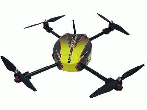
 The StitchCAM aerial imaging system is comprised of a survey drone, a Google Nexus™ tablet and proprietary software that works together to collect highly-refined crop images.
From the farmlands of the U.S. to the drought-stricken regions of Africa, the StitchCAM will help farmers and landowners increase profits and maximize their resources. The complete StitchCAM system is available to order for a Kickstarter pledge of $2,800 today through Aug. 8, 2014.
Bill Robertson, founder of SNAP Vision Technologies, was inspired to develop the StitchCAM after seeing the need his uncles, farmers in Iowa, had for reliable information about their crops. "I believe feeding the world in 2050 is attainable if technology is approachable and affordable enough for all farmers. It's time to put drones to work in applications that will make a difference to industry and to society," says Robertson.
The StitchCAM aerial imaging system is comprised of a survey drone, a Google Nexus™ tablet and proprietary software that works together to collect highly-refined crop images. The system is easy-to-use and requires no special training, yet is low-cost and durable enough to use in the field. To collect data, the user places the StitchCAM drone on the ground facing the desired area to map. Next, the user programs the flight plan by simply entering the dimensions of the survey area into the StitchCAM app that comes pre-loaded on the touchscreen tablet. Visual confirmation appears on the tablet as a red box around the survey area. Lastly, touch the "auto-launch" button on the tablet and the drone takes flight. A video of the StitchCAM in flight is available on the Kickstarter project page.
As the drone moves in a serpentine pattern over the survey area it captures and collects several ultra-high resolution color images, near-infrared information and geo-location data. After the survey is complete, the software on the tablet immediately processes the images for viewing right in the field. Farmers use the near-infrared data to evaluate whether plants are healthy or stressed, or to identify weed pressures. Landowners can use the information to assess areas that are being under-watered or over-watered and make adjustments to utilize water resources more wisely.
Currently farmers collect information about the well being of their crops by simply walking their fields or by using manned air flights, each one costing on average eight dollars per acre. Because the StitchCAM can fly lower and slower than an airplane it can capture imagery that is much more detailed than what can be captured from a traditional plane. The resulting mosaic of images is so highly defined the farmer can even identify individual corn, soy or grape plants and use the information to manage the crops accordingly. At the Kickstarter price of $2,800 the StitchCAM pays for itself after 350 acres of flight.
The StitchCAM system contains high-tech components in a rugged and reliable package. At the heart of the StitchCAM is its patent-pending V2 imaging sensor that captures high-resolution data. As a quadcopter, the drone aircraft can fly in and out of areas with trees, fly slow and resist wind gusts with precision. It can take off and land autonomously within a ten-foot circle. The compact quadcopter also folds up to fit into a portable box that can be safely carried and easily stored. Included with the system are the drone, the tablet, a battery and a battery charger. The system is ready to use out of the box after an initial charge of the tablet and the drone battery.
Specifications
- Chassis: Aircraft aluminum and carbon fiber
- Motors: Four 920 Kv brushless motors
- Measurements: 20 inches from motor to motor, 10-inch prop
- Weight: 3.8 pounds
- Battery: 5000mAh lithium polymer battery. One battery charge covers 40 acres.
Source:
Bill Robertson and SNAP Vision Technologies LLC