By Kalwinder KaurSep 12 2012
The U.S. Naval Research Laboratory Marine Meteorology Division (MMD), Monterey, California researchers will participate in a new three-year NASA field campaign focused on observing hurricanes from a complex, unique vantage point 65,000 ft over the Atlantic.
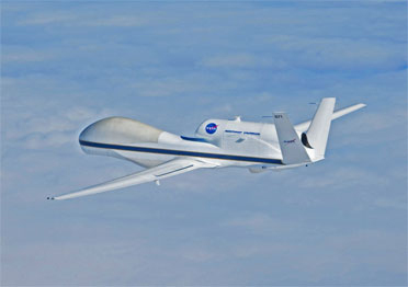
 NASA Global Hawk
The NRL team will examine the upper-level section of tropical cyclones (TCs), targeting hurricane outflow jets moving away from the storm center in controlled channels.
Based at NASA's Wallops Island Flight Facility on Virginia's Eastern Shore, the NRL team including research meteorologists will work on Dr. Scott Braun-led Hurricane and Severe Storm Sentinel (HS3) mission that focuses on evaluating the meteorological data collected by a pair of NASA Global Hawk unmanned aircraft attached to a suite of meteorological instrumentation.
The Global Hawk can be effectively deployed to investigate the storm from the surface to the outflow layer and to unravel the facts fundamental to TC intensity change.
Equipped with NASA-developed onboard remote sensors, one Global Hawk will perform target probing on the hurricane outflow layer and monitor other environmental conditions. The environmental Global Hawk also uses a system for adopting data observation and transmission capable dropsondes.
A second Global Hawk will target exploring the inner-core of the storm, based on NASA designed instruments like multi-frequency radiometer system for mapping rainfall rate and ocean surface winds, specifically on the intense hurricane eyewall. Global Hawk equips other NASA instruments such as conically scanning Doppler radar for monitoring hurricane's wind and rainfall structure and a radiometer system for analyzing precipitation features and evaluating large thermal anomaly in the hurricane eye.
In addition, Coupled Ocean/Atmosphere Mesoscale Prediction System Tropical Cyclone (COAMPS-TC) model will also be employed by the team in real time.
The NRL research team envisions the observations gathered during HS3 to enable evaluation of COAMPS-TC predictions, creating advancements in the forecast system.
Disclaimer: The views expressed here are those of the author expressed in their private capacity and do not necessarily represent the views of AZoM.com Limited T/A AZoNetwork the owner and operator of this website. This disclaimer forms part of the Terms and conditions of use of this website.