By Kalwinder KaurJun 4 2012
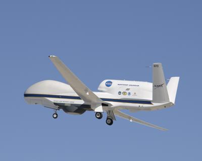
NASA will launch severe storm sentinels, an unmanned aircraft, over stormy skies in the beginning of this summer. It will enable forecasters and researchers to collect information on intensity changes and hurricane formation.
 HS3, Global Hawk, MODIS instrument
Many NASA centers have collaborated with federal and university partners for Hurricane and Severe Storm Sentinel (HS3) airborne mission that will enable detecting intensity change and hurricane formation within the Atlantic Ocean basin.
NASA's unmanned sentinels will autonomously take wings. The NASA Global Hawk is ideal for hurricane investigations as it can over-fly hurricanes at altitudes over 60,000 ft with flight durations of up to 28 h. Global Hawks were deployed for the Global Hawk Pacific (GloPac) environmental science mission and agency's 2010 Genesis and Rapid Intensification Processes (GRIP) hurricane mission.
Two Global Hawk aircraft and six different instruments will be used by HS3 during this summer that are being launched at a base of operations at Virginia-based Wallops Flight Facility.
HS3 will carry out the controversial role of the dry, hot, and dusty Saharan Air Layer in tropical storm formation and intensification. According to earlier studies, Saharan Air Layer can activate or hamper intensification. HS3 will observe whether deep convection within the storms’ inner-core region is a response to storms finding favorable sources of energy or a major driver of intensity change.
The HS3 mission will operate from June 1 to November 30, part of the Atlantic hurricane seasons. The 2012 mission will be performed from late August through early October.
Global Hawk aircraft will include instruments that observe the storms’ environment are the Cloud Physics Lidar (CPL), scanning High-resolution Interferometer Sounder (S-HIS), and the Advanced Vertical Atmospheric Profiling System (AVAPS) (dropsondes). The Tropospheric Wind Lidar Technology Experiment (TWiLiTE) Doppler wind lidar is expected to soar during the 2013 mission.
The set of instruments that will fly on the Global Hawk focusing on the inner region of the storms include the Hurricane Imaging Radiometer (HIRAD) multi-frequency interferometric radiometer, the High-Altitude Monolithic Microwave Integrated Circuit Sounding Radiometer (HAMSR) microwave sounder, and the High-Altitude Imaging Wind and Rain Airborne Profiler (HIWRAP) conically scanning Doppler radar.
Disclaimer: The views expressed here are those of the author expressed in their private capacity and do not necessarily represent the views of AZoM.com Limited T/A AZoNetwork the owner and operator of this website. This disclaimer forms part of the Terms and conditions of use of this website.