Industrial robots are now popular among industries for their versatile applications in production and assembly lines. Mobile robots are currently being employed as an alternative to human operation to explore hazardous and complex environments such as buildings prone to collapsing, ground or caves polluted by an industrial accident. However, in some cases, mapping of spaces becomes difficult.
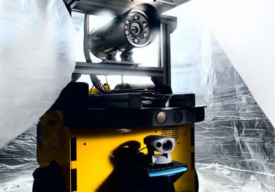
 Equipped with multiple sensors and optical cameras, the mobile robot roams over dangerous ground. Credit: Fraunhofer IOSB
A roaming land robot has now been developed by the researchers at the Fraunhofer Institute for Optronics, System Technologies and Image Exploitation IOSB in Karlsruhe. It is capable of independently reconnoitering and mapping uncharted terrain. With special algorithms and multi-sensor data, the robots explore through the unknown territory.
An algorithm toolbox that operates on an incorporated computer has been developed for the robot. In addition, it is equipped with various sensors including Odometry sensors that determine number of wheel revolutions, inertial sensors to calculate accelerations, while the distance-measuring sensors register clearance from steps, walls, trees and bushes. Cameras and laser scanners facilitate the mapping process by recording the environment. The resulting data will be interpreted by algorithms, thereby determining the robot's exact location, creating a map that will be constantly updated. This process is called simultaneous localization and mapping, or SLAM.
However, there exists certain limitation with mobility of robots such as the limited turning circle, falling objects or earthquake aftershocks. Hence, robots must be capable of navigating around obstacles, and during its operation in hazardous environments, the robot should have high recording capacity and quick recalculation of route for the subsequent processes.
The IOSB researchers will be demonstrating the mobile robot technology at the CeBIT trade fair, scheduled to take place between March 6 and 10.