Jul 18 2019
Over half of the world’s active volcanoes are not tracked using any instruments. Hence, even eruptions that could possibly have rung an alarm can take place without people at risk having an inkling of the imminent catastrophe.
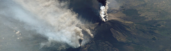 Satellite image of the erupting Etna taken from the International Space Station ISS in 2002. (Photo credit: NASA)
As a primary and early step towards a volcano early warning system, a research project headed by Sébastien Valade from the Technical University of Berlin (TU Berlin) and the GFZ German Research Centre for Geosciences in Potsdam developed a new volcano monitoring system which examines satellite images using—amongst other techniques—“artificial intelligence” (AI).
Through tests with data from latest events, Valade and his coworkers showed that their platform known MOUNTS (Monitoring Unrest from Space) can combine many sets of diverse types of data for a complete monitoring of volcanoes. The team’s results were reported in the journal Remote Sensing.
Of the 1500 active volcanoes around the world, nearly 85 erupt every year. Owing to the cost and trouble of maintaining instrumentation in volcanic surroundings, less than half of the active volcanoes are tracked using ground-based sensors, and even less are considered properly monitored. Volcanoes said to be dormant or extinct are usually not instrumentally tracked at all, but may experience massive and unanticipated eruptions, as was the case for the Chaitén volcano in Chile in 2008 which erupted after 8000 years of being dormant.
Eruptions often preceded by precursory signals
Satellites can offer vital data when ground-based monitoring is less or absent. Continuous long-term observations from space are crucial to properly detecting signs of volcanic turbulence. Eruptions are frequently – but not always – preceded by precursory signals which may be present for a few hours to a few years. These signals can include ground deformation, temperature increase, variations in seismic behavior, gas emissions, or several of the above.
“Apart from seismicity, all of these can be monitored from space by exploiting various wavelengths across the electromagnetic spectrum”, says Sébastien Valade, leader of the MOUNT project. It is sponsored by GEO.X, a research network for geosciences in Berlin and Potsdam established in 2010, and carried out at TU Berlin and GFZ.
With the MOUNTS monitoring system, we exploit multiple satellite sensors in order to detect and quantify changes around volcanoes”, he adds. “And we also integrated seismic data from GFZ's worldwide GEOFON network and from the United States Geological Survey USGS.
Sébastien Valade, Project Leader of MOUNT, TU Berlin and GFZ
One aspect of the project was to test whether AI algorithms could be effectively incorporated into the data analysis process. These algorithms were mostly prepared by Andreas Ley from the TU Berlin. He applied so-called artificial neural networks to automatically recognize large deformation events.
The scientists taught them with computer-generated images imitating real satellite images. From this massive number of synthetic examples, the software learned to recognize large deformation events in real satellite data previously unknown to it. This field of data science is referred to as “machine learning”.
“For us, this was an important 'test balloon' to see how we can integrate machine learning into the system,” says Andreas Ley. "Right now, our deformation detector just solves a single task. But our vision is to integrate several AI tools for different tasks. Since these tools usually benefit from being trained on large amounts of data, we want to make them learn continuously from all the data the system gathers on a global scale."
MOUNTS monitors 17 volcanoes worldwide
The key challenges he and his co-authors had to face with were managing the large amounts of data, and software engineering problems.
But these problems can be solved”, says Sébastien Valade. “I am deeply convinced that in the not so far future, automated monitoring systems using AI and data from different sources like satellite remote sensing and ground-based sensors will help to warn people in a more timely and robust fashion.
Sébastien Valade, Project Leader of MOUNT, TU Berlin and GFZ
As of now, the analysis delivered by the MOUNTS monitoring system allows for a complete understanding of different processes in various volcanic and climatic settings worldwide: from the propagation of magma underneath the surface to the emplacement of volcanic material during the eruption, as well as the morphological variations of affected areas, and the emission of gases into the atmosphere.
The scientists positively tested MOUNTS on several recent events like the Krakatau eruption in Indonesia in 2018 or eruptions in Guatemala and Hawaii. The system at present tracks 17 volcanoes globally including Etna in Italy and Popocatépetl in Mexico. The website of the system is freely accessible, and—thanks to the worldwide coverage and free access to the core data—can easily integrate new data.
Source: https://www.gfz-potsdam.de/en